
Wembury Beach & Hooe Lake Plymouth
This images below are a collaboration of work from four photographers local to Torbay. These photographers are Mike Bond, Stuart Chapman ARPS CPAGB, Alex Hamer and Dave Collerton. The idea behind this exhibition is to better understand how four very different photographers see the same landscapes at the same time, standing in the same places and looking at the very same scenes. Even given these conditions, it is quite amazing that each photographer has been able to put their own spin on what's in front of them and as such, have been able to capture such different images.
Why Wembury Beach?
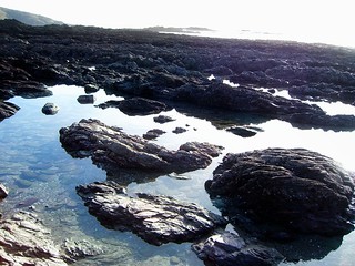
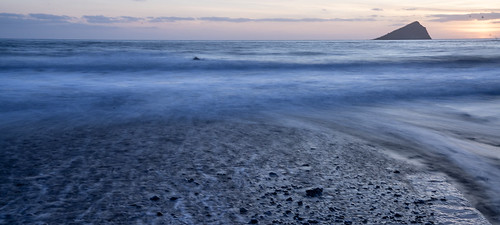
Owned by the National Trust with its own Marine Conservation Centre and guided rock pool rambles, Wembury is an Area of Outstanding Natural Beauty (AONB) offering safe, clean bathing from gently shelving sand and shale, with beautiful cliff walks to Bovisand in the west and Newton Ferrers/Noss Mayo to the east. It's also a popular spot for surfing and kayaking. With a swell of up to 10 feet, it's fantastic for surfers of all abilities. You can also explore this part of the coast and the River Yealm by kayak although landing is not permitted on the Great Mewstone as it's a nature reserve and home to a wide variety of seabirds.
If you want to explore the beach and local area car parking is available at the National Trust Car Park situated between St Werburgh’s church and the beach. The Old Mill Cafe is situated adjacent to the beach and provides a good selection of food and adjacent to the beach is the Marine Centre which provides information about the sea and beach environment in the region. The coastal path touches the beach at this point and there are excellent walks for miles in each direction from the beach, with magnificent views along the coast.
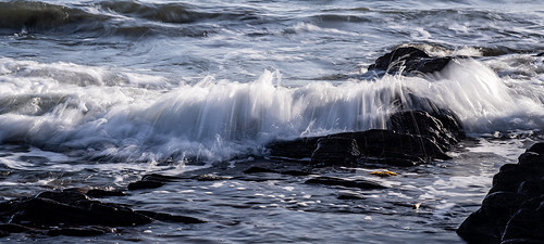
Why Hooe Lake?
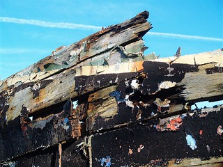
Hooe is situated adjacent to the estuary of the River Plym. It consists of two areas, Higher Hooe and Lower Hooe. Lower Hooe includes the area near Hooe Lake and the old barn from the former Hooe Barton Farm which was demolished in 1969. Areas around Hooe include Radford to the east, Turnchapel to the north-west, and Jennycliff Bay to the west. Hooe has woodland and farmland to the south. The site now covers 14 hectares and although privately owned and managed, it is accessible to the public. The site is tidal, containing mudflats and open water habitats. The site is designated as a County Wildlife Site because of the mudflats, a UK Biodiversity Action Plan (UKBAP) priority habitat that's present at low water.
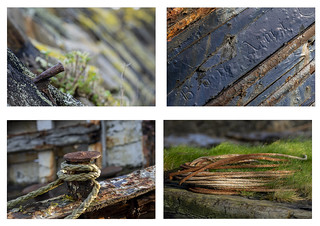
There are five quarries situated around Hooe Lake, all disused and in disrepair. The largest, Hooe Lake Quarry, was used to store fuel by the Ministry of Defence until the 1970s after its useful life as a limestone quarry. Adjacent to the lake at the river end of the estuary are the remains of the old Turnchapel Branch swing bridge used for trains to access Turnchapel from the Oreston side from 1897. It was closed in the 20th century shortly after the Second World War. Since then it has remained in a state of disrepair. The bridge itself has now gone but the structure still remains.
At one end of the dam separating the freshwater Radford Lake from tidal Hooe Lake sits an early 19th-century folly known as Radford Castle.
Here are just a few of the 36 images captured on the day. Click on any image to see the full album.
If you see an image you would like to purchase, please contact us and we will liaise with the photographer on your behalf. You can contact us here.
Some Technical Detail
- Stuart Chapman: Stuart chose to use his 50MP, 35mm full-frame Sony Alpha A1 for this project. His lens choices for this trip were the Sony 14mm, 16-35, 24-105 and 70-200. Stuart is built like Arnold Schwarzenegger as you can imagine from carting all this gear around! For post-processing, Stuart is a big fan of Adobe Lightroom and Photoshop which he uses on Apple Mac hardware. Stuart shoots in colour but often processes his images in the contrasty monochrome style but here he has opted mostly for colour.
- Alex Hamer: Like Stuart, Alex used his Sony A1 throughout the shoot. This was combined with a variety of lenses including the 35mm f1.4, 16-35 f2.8, 24-70 f2.8 and 100-400 f5.6-6.3. For post-processing, Alex used Adobe Lightroom and Photoshop to process all of his images. Alex works on a comprehensively specified Windows 11 PC as well as on a Windows 11 laptop when required.
- Mike Bond: Mike used Nikon for most of his career as a professional photographer moving more latterly to Fuji before briefly retuning to Nikon. Most recently, Mike has converted to Sony and for this shoot he used his Sony A7r4 with the 24-105 f4 and 16-35 f4. Like both Stuart and Alex. Mike uses Adobe Lightroom and Photoshop for post processing which sits on both Apple Mac and PC hardware.
- Dave Collerton: Dave is very much into older camera technology and for this shoot he choose to use the tiny Casio EX-Z850 compact along with the Olympus Evolt E-300. Both cameras utilise CCD sensors with the Olympus E-300 adopting a 4/3 mount and a CCD sensor from Kodak. For this shoot he opted to carry light and used just the Zuiko 14-54 f2.8-3.5 with the Olympus E-300. For post-processing, much like his use of cameras, Dave uses a variety of software including On1 2024, Affinity Photo and more recently. Adobe Lightroom and Photoshop. Dave uses Windows based hardware including a recently built desktop Windows 11 PC and an older Windows 10 laptop.
Looking for support for your commercial event?
Pixtures is able to undertake all types of photographic projects from major events through to retail, fashion, architecture, real estate, portraiture and much more besides. If you need support, irrespective of the size of your project or your budget, please feel free to contact us to talk about your needs. Contact us today for more information and to get the ball rolling.